


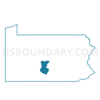
MT. UNION WD 02, Huntingdon County, Pennsylvania
About
Outline

Summary
| Unique Area Identifier | 659933 |
| Name | MT. UNION WD 02 |
| County | Huntingdon County |
| State | Pennsylvania |
| Area (square miles) | 0.32 |
| Land Area (square miles) | 0.32 |
| Water Area (square miles) | 0.00 |
| % of Land Area | 100.00 |
| % of Water Area | 0.00 |
| Latitude of the Internal Point | 40.38247250 |
| Longtitude of the Internal Point | -77.89017390 |
Maps


Graphs
Select a template below for downloading or customizing gragh for MT. UNION WD 02, Huntingdon County, Pennsylvania


Neighbors
Neighoring Voting District (by Name) Neighboring Voting District on the Map
- MT. UNION WD 01, Huntingdon County, PA
- MT. UNION WD 03, Huntingdon County, PA
- SHIRLEY TWP DIST MT. UNION, Huntingdon County, PA